SQL Server, PostGIS, STDifference and Precision
Today I encountered a problem related to the OGC difference function. I
will describe this problem in this blog. I created a sort
of minimal sample, without database, and present that here.
The problem
The problem I encountered is precision: both SQL Server (where I
encountered it) and
PostGIS (where I verified it) do not handle the situation described
here sufficiently. The results is a polygon with
two spikes
which should
not be there. The
cause must be imprecision of floating point types. The message is:
be
warned!
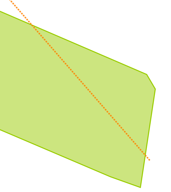
The situation is as following: there is a
parcel.
That parcel is cut
into two pieces (I will explain below how). One piece is thrown away,
the other piece is kept. That kept piece is subtracted from the
original parcel. What you would expect is having the original piece
that was earlier thrown away. But what is happening is that you
get one or two spikes extra...
The parcel and the cutline are shown here:
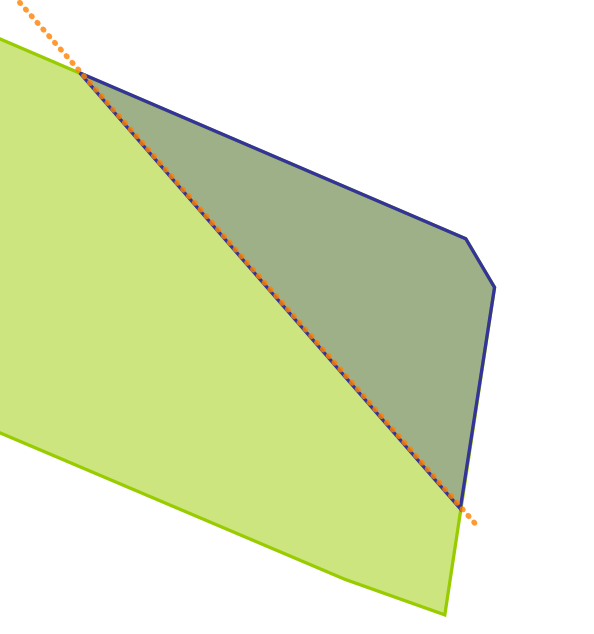
Cutting into two pieces
We cut (for this experiment) the
polygon into two pieces by buffering the cutline, and subtracting (with
STDifference) that
from the parcel. The cutline is shown in the figure above as the dotted
red line. Then we
keep one of the two resulting polygons using the STGeometryN function.
By trying we get the left piece
which we want to keep by index 2.
So this piece of SQL is, for SQL Server:
select geometry::STGeomFromWKB(0x0103000000010000001A00000023DBF97EE316064146B6F3FDD32513415A643BDFD216064175931804E225134196438B6C52150641C976BE9F34261341F6285C8F06150641022B871641261341F853E3A5D3140641E17A14AE50261341B81E85EBFB120641A4703D8A142713414E6210584D120641AC1C5A64602713414E621058431106414E621058C9271341A01A2FDD1B11064121B07268D8271341F4FDD478571006411904560ECF271341448B6CE7DD0F06418195438BC1271341F6285C8F6A0F06413BDF4F0DA72713410E2DB29D360F06416F1283C091271341E5D022DB070F0641F6285C0F7227134160E5D022DA0E06416F1283404F271341448B6CE7D30E0641F853E3A52427134154E3A59BE60E06411904568E07271341643BDF4F0C0F0641D7A3703DFC2613414A0C022B100F064125068115FB26134191ED7C3F310F0641B6F3FDD4F42613414C378941F11006414A0C022BA0261341EC51B81ECC1206413BDF4F0D40261341022B87167514064125068115F1251341B4C876BE8C160641C74B37897F25134121B07268C6160641508D976E7525134123DBF97EE316064146B6F3FDD3251341,28992)
.STDifference(geometry::STGeomFromText('LINESTRING(180955 313700,180920 313740)', 28992).STBuffer(0.1)).STGeometryN(2)
And for PostGIS it is:
select ST_GeometryN(ST_Difference(
ST_SetSRID('0103000000010000001A00000023DBF97EE316064146B6F3FDD32513415A643BDFD216064175931804E225134196438B6C52150641C976BE9F34261341F6285C8F06150641022B871641261341F853E3A5D3140641E17A14AE50261341B81E85EBFB120641A4703D8A142713414E6210584D120641AC1C5A64602713414E621058431106414E621058C9271341A01A2FDD1B11064121B07268D8271341F4FDD478571006411904560ECF271341448B6CE7DD0F06418195438BC1271341F6285C8F6A0F06413BDF4F0DA72713410E2DB29D360F06416F1283C091271341E5D022DB070F0641F6285C0F7227134160E5D022DA0E06416F1283404F271341448B6CE7D30E0641F853E3A52427134154E3A59BE60E06411904568E07271341643BDF4F0C0F0641D7A3703DFC2613414A0C022B100F064125068115FB26134191ED7C3F310F0641B6F3FDD4F42613414C378941F11006414A0C022BA0261341EC51B81ECC1206413BDF4F0D40261341022B87167514064125068115F1251341B4C876BE8C160641C74B37897F25134121B07268C6160641508D976E7525134123DBF97EE316064146B6F3FDD3251341'
 ::geometry, 28992)
, (ST_Buffer(ST_GeomFromText('LINESTRING(180955 313700,180920 313740)',28992),0.1))), 2)
Note that the 28992 is just an SRID of a coordinate system (the Dutch),
it probably works (or better stated: does not work) with any coordinate
system. The result is this:

Subtracting one of the pieces from the original
After cutting we subtract the piece we kept from the original parcel.
This will result in the other
piece. In fact we get the area covered by the small buffer as well, but
that
is hardly visible, and is not important for this story.
This is how it should look like:
And this is the complete query in SQL Server:
select
geometry::STGeomFromWKB(0x0103000000010000001A00000023DBF97EE316064146B6F3FDD32513415A643BDFD216064175931804E225134196438B6C52150641C976BE9F34261341F6285C8F06150641022B871641261341F853E3A5D3140641E17A14AE50261341B81E85EBFB120641A4703D8A142713414E6210584D120641AC1C5A64602713414E621058431106414E621058C9271341A01A2FDD1B11064121B07268D8271341F4FDD478571006411904560ECF271341448B6CE7DD0F06418195438BC1271341F6285C8F6A0F06413BDF4F0DA72713410E2DB29D360F06416F1283C091271341E5D022DB070F0641F6285C0F7227134160E5D022DA0E06416F1283404F271341448B6CE7D30E0641F853E3A52427134154E3A59BE60E06411904568E07271341643BDF4F0C0F0641D7A3703DFC2613414A0C022B100F064125068115FB26134191ED7C3F310F0641B6F3FDD4F42613414C378941F11006414A0C022BA0261341EC51B81ECC1206413BDF4F0D40261341022B87167514064125068115F1251341B4C876BE8C160641C74B37897F25134121B07268C6160641508D976E7525134123DBF97EE316064146B6F3FDD3251341,28992)
.STDifference
(
  (
 select
 geometry::STGeomFromWKB(0x0103000000010000001A00000023DBF97EE316064146B6F3FDD32513415A643BDFD216064175931804E225134196438B6C52150641C976BE9F34261341F6285C8F06150641022B871641261341F853E3A5D3140641E17A14AE50261341B81E85EBFB120641A4703D8A142713414E6210584D120641AC1C5A64602713414E621058431106414E621058C9271341A01A2FDD1B11064121B07268D8271341F4FDD478571006411904560ECF271341448B6CE7DD0F06418195438BC1271341F6285C8F6A0F06413BDF4F0DA72713410E2DB29D360F06416F1283C091271341E5D022DB070F0641F6285C0F7227134160E5D022DA0E06416F1283404F271341448B6CE7D30E0641F853E3A52427134154E3A59BE60E06411904568E07271341643BDF4F0C0F0641D7A3703DFC2613414A0C022B100F064125068115FB26134191ED7C3F310F0641B6F3FDD4F42613414C378941F11006414A0C022BA0261341EC51B81ECC1206413BDF4F0D40261341022B87167514064125068115F1251341B4C876BE8C160641C74B37897F25134121B07268C6160641508D976E7525134123DBF97EE316064146B6F3FDD3251341,28992)
 .STDifference(geometry::STGeomFromText('LINESTRING(180955 313700,180920 313740)', 28992).STBuffer(0.1)).STGeometryN(2)
 )
)
And in PostGIS:
select ST_Perimeter(ST_Difference(
ST_SetSRID('0103000000010000001A00000023DBF97EE316064146B6F3FDD32513415A643BDFD216064175931804E225134196438B6C52150641C976BE9F34261341F6285C8F06150641022B871641261341F853E3A5D3140641E17A14AE50261341B81E85EBFB120641A4703D8A142713414E6210584D120641AC1C5A64602713414E621058431106414E621058C9271341A01A2FDD1B11064121B07268D8271341F4FDD478571006411904560ECF271341448B6CE7DD0F06418195438BC1271341F6285C8F6A0F06413BDF4F0DA72713410E2DB29D360F06416F1283C091271341E5D022DB070F0641F6285C0F7227134160E5D022DA0E06416F1283404F271341448B6CE7D30E0641F853E3A52427134154E3A59BE60E06411904568E07271341643BDF4F0C0F0641D7A3703DFC2613414A0C022B100F064125068115FB26134191ED7C3F310F0641B6F3FDD4F42613414C378941F11006414A0C022BA0261341EC51B81ECC1206413BDF4F0D40261341022B87167514064125068115F1251341B4C876BE8C160641C74B37897F25134121B07268C6160641508D976E7525134123DBF97EE316064146B6F3FDD3251341'::geometry,28992)
,
(select ST_GeometryN(ST_Difference(
ST_SetSRID('0103000000010000001A00000023DBF97EE316064146B6F3FDD32513415A643BDFD216064175931804E225134196438B6C52150641C976BE9F34261341F6285C8F06150641022B871641261341F853E3A5D3140641E17A14AE50261341B81E85EBFB120641A4703D8A142713414E6210584D120641AC1C5A64602713414E621058431106414E621058C9271341A01A2FDD1B11064121B07268D8271341F4FDD478571006411904560ECF271341448B6CE7DD0F06418195438BC1271341F6285C8F6A0F06413BDF4F0DA72713410E2DB29D360F06416F1283C091271341E5D022DB070F0641F6285C0F7227134160E5D022DA0E06416F1283404F271341448B6CE7D30E0641F853E3A52427134154E3A59BE60E06411904568E07271341643BDF4F0C0F0641D7A3703DFC2613414A0C022B100F064125068115FB26134191ED7C3F310F0641B6F3FDD4F42613414C378941F11006414A0C022BA0261341EC51B81ECC1206413BDF4F0D40261341022B87167514064125068115F1251341B4C876BE8C160641C74B37897F25134121B07268C6160641508D976E7525134123DBF97EE316064146B6F3FDD3251341'::geometry,28992)
,(ST_Buffer(ST_GeomFromText('LINESTRING(180955 313700,180920 313740)', 28992),0.1))),2)
)))
Results
To my surprise I got two spikes in SQL Server. To verify this, I looked
into PostGIS. I got two spikes as well. First I
thought it was caused by precision, going to WKT and back. But also if
you use WKB, or if you use the geometry from the underlying database
(not shown here), you will get the same. So it is the imprecision of
the handling. When varying the cutline a bit (changing 180955 to
180960), I get one spike in SQL Server and still two in PostGIS.
The spikes are shown here, bordering the blue result:

The
perimeter
of the result is interesting. The result, without spikes, should be
92.5 meter. But including the spikes it is 151.792871568541 (in SQL
Server, using the function .STLength() and 151.792880859545 (in
PostGIS, using the function ST_Perimeter(...).
The
area is
everywhere about 295.4 square meter, with or without spikes, indicating
that the spikes have an area about zero (so those are real spikes).
Why would you do such a thing... Creating a parcel, cutting, throwing
away one, subtracting and getting the other one...
Well, I was just testing our application.
Our application has WebGIS functionality to create parcels. And to cut
parcels into two pieces. And to throw away pieces. And to fill-up space
which is left from a parcel and a piece. So just this scenario. And to
my annoyance, often you get spikes! This project is done with SQL
Server, and we get spikes. But this little research shows that, would
we have done it with PostGIS, we would have had resulting spikes as
well.
It is as a simple mathematical exercise. We cut 5 into two pieces, 3
and 2. We throw away the 2 and keep the 3. We subtract 3 from our 5.
And we get the 2 back, of course. In geometry we subtract (difference)
twice but that is just because the
cut
is not an OGC operation. So we trick it.
Note that I didn't get this
just once. I got it several times for different geometries. Note also that it can easily be solved using a STBuffer of -0.00001 on the resulting polygon, which will eliminate the spikes and have no visual impact (it
has an impact though...).
With Boost.Geometry
Of course I was curious what Boost.Geometry would do with this.
The buffer of Boost.Geometry is not completely implemented, so I create
the buffer in SQL Server,
saving the WKB.
select geometry::STGeomFromText('LINESTRING(180955 313700,180920 313740)', 28992).STBuffer(0.1).STAsBinary()
and draft some C++ code:
template <typename T>
void test_difference_parcel_precision()
{
    namespace bg = boost::geometry;
    typedef bg::model::d2::point_xy<T> point_type;
    typedef bg::model::polygon<point_type> polygon_type;
    typedef std::vector<boost::uint8_t> byte_vector;

    polygon_type parcel, buffer;

    {
        byte_vector wkb;
        bg::hex2wkb("0103000000010000001A00000023DBF97EE316064146B6F3FDD32513415A643BDFD216064175931804E225134196438B6C52150641C976BE9F34261341F6285C8F06150641022B871641261341F853E3A5D3140641E17A14AE50261341B81E85EBFB120641A4703D8A142713414E6210584D120641AC1C5A64602713414E621058431106414E621058C9271341A01A2FDD1B11064121B07268D8271341F4FDD478571006411904560ECF271341448B6CE7DD0F06418195438BC1271341F6285C8F6A0F06413BDF4F0DA72713410E2DB29D360F06416F1283C091271341E5D022DB070F0641F6285C0F7227134160E5D022DA0E06416F1283404F271341448B6CE7D30E0641F853E3A52427134154E3A59BE60E06411904568E07271341643BDF4F0C0F0641D7A3703DFC2613414A0C022B100F064125068115FB26134191ED7C3F310F0641B6F3FDD4F42613414C378941F11006414A0C022BA0261341EC51B81ECC1206413BDF4F0D40261341022B87167514064125068115F1251341B4C876BE8C160641C74B37897F25134121B07268C6160641508D976E7525134123DBF97EE316064146B6F3FDD3251341", std::back_inserter(wkb));
        bg::read_wkb(wkb.begin(), wkb.end(), parcel);
    }
    {
        byte_vector wkb;
        bg::hex2wkb(
"01030000000100000083000000000032FCD716064100009E998F25134100000706D81606410040A4998F2513410000DA0FD816064100C0E6998F2513410000A819D81606410080659A8F25134100806A23D816064100C0209B8F25134100801E2DD81606410080189C8F2513410000BE36D816064100404D9D8F25134100004540D816064100C0BE9E8F2513410000AF49D816064100806DA08F2513410000F752D8160641008059A28F2513410000195CD816064100C082A48F25134100800F65D81606410080E9A68F2513410000D66DD816064100408EA98F25134100006876D816064100C070AC8F2513410000C17ED8160641000091AF8F2513410080DC86D816064100C0EFB28F25134100009E8ED816064100C081B68F2513410080EC95D816064100803ABA8F2513410080C79CD8160641000018BE8F25134100002FA3D8160641008017C28F251341008022A9D8160641000037C68F2513410080A1AED8160641000074CA8F2513410000ACB3D81606410040CCCE8F251341000042B8D816064100403DD38F251341000062BCD81606410000C5D78F25134100000DC0D8160641000061DC8F251341000042C3D816064100000FE18F251341000001C6D81606410080CCE58F251341008049C8D8160641004097EA8F25134100001BCAD816064100006DEF8F251341008075CBD816064100804BF48F251341008058CCD8160641004030F98F2513410000C4CCD8160641000019FE8F2513410080B7CCD81606410080030390251341008032CCD81606410000ED0790251341000035CBD81606410000D40C902513410080BEC9D81606410040B511902513410000CFC7D816064100408F1690251341008065C5D816064100005F1B90251341008082C2D81606410080222090251341000025BFD81606410080D7249025134100004DBBD816064100807B29902513410080FAB6D816064100800C2E9025134100002DB2D816064100C08732902513410080E3ACD81606410000EB369025134100801EA7D81606410000343B902513410000DEA0D81606410080603F902513410080209AD816064100406E43902513410080209AC015064100406E43302613410080FC92C015064100004F473026134100008B8BC01506410040F64A302613410000D083C015064100C0634E302613410000D17BC0150641008097513026134100009273C015064100409154302613410000186BC015064100C050573026134100806762C01506410000D6593026134100808559C01506410000215C3026134100007650C01506410000315E3026134100003E47C015064100800660302613410000E23DC01506410000A1613026134100006734C015064100800063302613410080D12AC015064100C024643026134100002621C015064100800D653026134100006917C015064100C0BA653026134100809F0DC015064100402C66302613410000CE03C015064100006266302613410000F9F9BF15064100C05B6630261341000026F0BF1506410040196630261341000058E6BF15064100809A6530261341008095DCBF1506410040DF64302613410080E1D2BF1506410080E76330261341000042C9BF15064100C0B262302613410000BBBFBF1506410040416130261341000051B6BF1506410080925F30261341000009ADBF1506410080A65D302613410000E7A3BF15064100407D5B302613410080F09ABF150641008016593026134100002A92BF15064100C071563026134100009889BF15064100408F533026134100003F81BF15064100006F503026134100802379BF1506410040104D3026134100006271BF15064100407E49302613410080136ABF1506410080C5453026134100803863BF1506410000E841302613410000D15CBF1506410080E83D302613410080DD56BF1506410000C9393026134100805E51BF15064100008C35302613410000544CBF15064100C03331302613410000BE47BF15064100C0C22C3026134100009E43BF15064100003B28302613410000F33FBF15064100009F23302613410000BE3CBF1506410000F11E302613410000FF39BF1506410080331A302613410080B637BF15064100C06815302613410000E535BF150641000093103026134100808A34BF1506410080B40B302613410080A733BF15064100C0CF063026134100003C33BF1506410000E7013026134100804833BF1506410080FCFC2F2613410080CD33BF150641000013F82F2613410000CB34BF15064100002CF32F26134100804136BF15064100C04AEE2F26134100003138BF15064100C070E92F26134100809A3ABF1506410000A1E42F26134100807D3DBF1506410080DDDF2F2613410000DB40BF150641008028DB2F2613410000B344BF150641008084D62F26134100800549BF1506410080F3D12F2613410000D34DBF150641004078CD2F26134100801C53BF150641000015C92F2613410080E158BF1506410000CCC42F2613410000225FBF15064100809FC02F2613410080DF65BF15064100C091BC2F2613410080DF65D716064100C091BC8F2513410080036DD71606410000B1B88F25134100007574D716064100C009B58F2513410000307CD716064100409CB18F25134100002F84D7160641008068AE8F25134100006E8CD716064100C06EAB8F2513410000E894D71606410040AFA88F2513410080989DD716064100002AA68F25134100807AA6D71606410000DFA38F25134100008AAFD71606410000CFA18F2513410000C2B8D71606410080F99F8F25134100001EC2D716064100005F9E8F251341000099CBD71606410080FF9C8F25134100802ED5D71606410040DB9B8F2513410000DADED71606410080F29A8F251341000097E8D71606410040459A8F251341008060F2D716064100C0D3998F251341000032FCD716064100009E998F251341", std::back_inserter(wkb));
        bg::read_wkb(wkb.begin(), wkb.end(), buffer);
    }
    bg::correct(parcel);
    bg::correct(buffer);

    std::vector<polygon_type> pieces;
    bg::difference(parcel, buffer, pieces);

    std::vector<polygon_type> filled_out;
    bg::difference(parcel, pieces.back(), filled_out);

    std::cout << std::setprecision(16) << bg::wkt(filled_out.front()) << std::endl;
    std::cout << bg::area(filled_out.front()) << std::endl;
    std::cout << bg::perimeter(filled_out.front()) << std::endl;
}
We are using WKB here to not loose precision. I run this with three
different numeric types (float, double and ttmath high precision).
And
that
is the essence of Boost.Geometry! Not one type! Many types! All types!
int main(int, char* [])
{
    test_difference_parcel_precision<float>();
    test_difference_parcel_precision<double>();
    test_difference_parcel_precision<ttmath_big>();
    return 0;
}
Using these three types we get:
- float: one spike, perimeter 136.28
- double: two spikes, perimeter 151.793
- ttmath: zero spikes, correct result, perimeter
92.50548050416428971188559805054187252
Conclusions
- SQL Server is not perfect, it can cause spikey features
- PostGIS is not perfect, it can cause spikey features
- The cause is not WKT, nor it is WKB
- Boost.Geometry, using double, is not perfect because it
causes the same spikey features
- Boost.Geometry, using ttmath, gives the correct results
- Boost.Geometry, using float, gives one spikey feature
- Changing the cutline a bit causes only one spikey feature
within SQL Server, still two in PostGIS, and zero in Boost.Geometry
(with all numeric types).
- Be aware
of floating point precision