Free Shapefile of Countries of the World
Note: read also part 2 and part 3 of this blog.
I'm always surprised that it is hard to find a good shapefile with
world countries. I need country vector data for Boost.Geometry sample
data. There is some there but I want to have another set. I want to
have it as WKT (Well-Known Text) and I can use a shapefile as input.
Asking Google for "free world map shapefile" you get:
- aprs
(1), with also a modified version
- blue
marble requires registration, but (probably) the
same set can be downloaded from the next entry
- brothersoft,
serving blue marble data (2)
- mapcruzin
(leading to no
countries but several interesting other shapefiles)
Via my company,
Geodan,
you can also download a worldmap,
here
(requiring mailing your contact information) (3)
Via free gis data,
here,
there is a hit on ESRI, leading to this
site,
leading to annual subscriptions etc.. I skipped this one.
Via similar terms ("countries") we also find:
- mapping
hacks, serving three world files (4)
- actually originating from this site,
which has a more actual version (5)
- a file from openmap here,
called cntry02 (6)
- and finally (via "cntry08") we find ESRI data here
(7)
I've downloaded these shapefiles. It gives me (file dates):
- is from 2002, modified in 2009 for Antarctica
- is from 1996
- is from 2003
- is from 2004
- is from 2008
- is from 2002
- is from 2008
The Netherlands
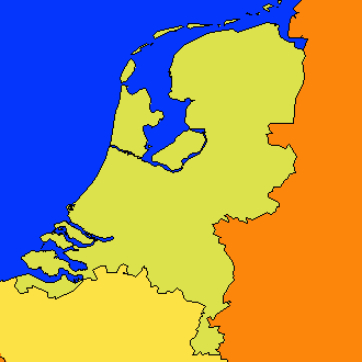
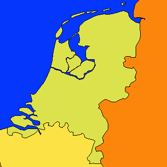
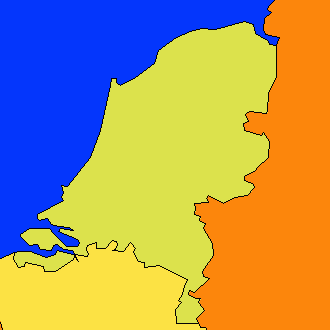
Let's first show my country, the Netherlands:

All borders through each other look quite messy... But let's
concentrate on the data.
Southern
Flevoland,
a polder, already existing since 1968, is still not there on
maps from 1 (aprsworld, green) and 2 (blue marble, so blue). Of course
it is present on the map of my company 3 (geodan, red), because Geodan
of course takes care for its own country. Southern Flevoland is also
present on all newer maps (5, pink, 6 orange, 7 gray). But on 5
and 6 it has a planned but not realized polder (Markerwaard)
included. So best
for the Netherlands are 3 and 7.
Of
the five inhabited islands along the Waddenzee, 7 depicts only two. So
here 3 is the best choice (of course, it is our country, and note that
for the rest this
is not a commercial talk)
For the whole world, 6 and 7 are quite similar in nearly all aspects
Uruguay
Let's now look at a country not part of Europe or US. I select Uruguay:
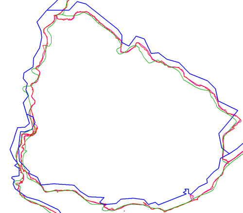
The blue vectors are quite rough and shifted to the west and north.
Green lines are looking nice for a map on this scale, but deviate a bit
from all other maps.
Let's now take a look in Google Earth. For this, we need to create a
KML file... hmm, shp2kml cannot be downloaded (blank website
saying
Missing ID).
OK, we use PostGIS then, it can create KML and WKT (we need it below).
shp2pgsql -s4326 world.shp world1 > world1.sql
etc
So I created a database called
blog
and executed these SQL files.
Five minutes later (PostGIS is great) I do:
psql
"-F " -A -n -t -q -Upostgres -dblog "-cselect
'<Placemark>',ST_AsKml(the_geom),'</Placemark>'
from world2 where name='Uruguay'" -otworld2.kml
Doing this for all tables and reworking the KML's a bit
(adding
headers etc) gives me:

Considering Google Maps as our Single Point of Truth, we can
discard the blue lines from Blue Marble, and might think that the green
lines are also wrong. The rest is following the borders more or less
but we need to zoom in to judge it better.
This is the new detail on a border:
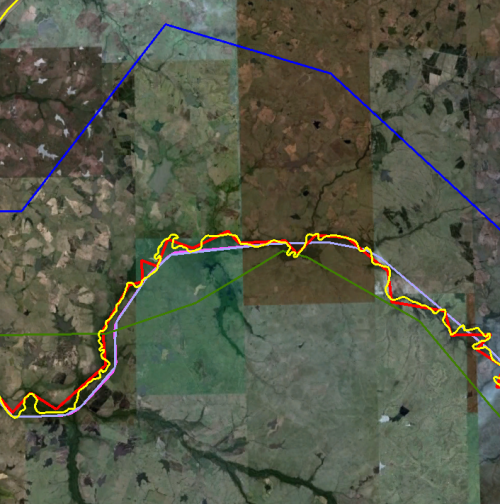
The
Yellow line is Google's line. The red line is following it, probably a
bit too much. For a global scale, the other ones (4,5,6,7) are doing
well here.
Caspian Sea
Looking
at global level, we see immediately one thing, on which we zoom in
here: it is surprising that the Caspian sea is not
included
in map 6 and 7. So the country borders are just across the sea... Not
so good.

Not
so good. So let's discard 6 and 7. We also see that the red lines (3)
are too detailed, also here. Discard 3. Blue (2) and green (1) was
already discarded before. So we keep 4 and 5, which are roughly the
same. So I decide to keep the more actualy one: 5.
Decision
So
we conclude, based on a few samples (and some more but not described
here), that the file TM_WORLD_BORDERS-0.3.zip from
Thematic
Mapping is the best shapefile to use for worldscale countries
(even though it contains the Markerwaard).
Country number and
validity
We did not consider attributes, and our research was
still rough.
An important aspect we want to consider is geometric validity. And,
even more important, the number of countries, it can differ over years,
but the differences are sometimes still surprising.
| Dataset |
Invalid (SQL Server) |
Invalid (PostGIS) |
#Countries |
Year |
| 1 |
1 |
1 |
244 |
2002 / 2009 |
| 2 |
4 |
3 |
239 |
1996 |
| 3 |
34 |
5 |
253 |
2003 |
| 4 |
5 |
6 polygons |
251 (3784 polygons (this dataset
contains polygonsp; not multi-polygons) |
2004 |
| 5 |
5 |
4 |
246 |
2008 |
| 6 |
3 |
0 |
251 |
2002 |
| 7 |
2 |
7 |
249 |
2008 |
About
the countries themselves, I just glanced through the
differences
using a query, comparing ISO3 country codes, getting this table:

We see some inconsistent and some missing ISO codes, and some countries
not in the one but in the other, and vice versa.
Conclusion
I think a good and free shapefile of the world is still
welcome.